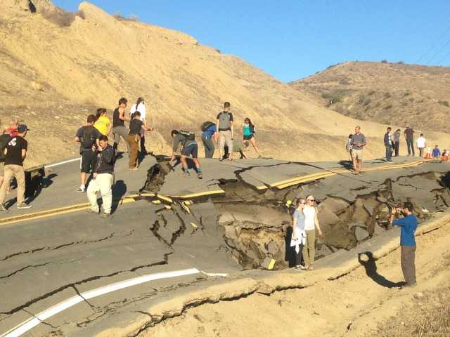
The still-closed Vasquez Canyon Road became an unexpected tourist stop Saturday as dozens of people showed up to get an up-close look at the warped Santa Clarita Valley roadway.
Local residents and passersby alike could be seen Saturday afternoon snapping selfies near the crumbled, twisted section of the road, which was closed Thursday after the ground under the pavement began shifting and lifting.
One man even brought out his drone to take video and photos of the scene from the air.
#SignalNews: The still-closed Vasquez Canyon Road became an unexpected tourist stop Saturday as dozens of people showed up to get an up-close look. http://bit.ly/21b1Ldd
Posted by Santa Clarita Valley Signal on Saturday, November 21, 2015
Among those who made a detour stop at the site Saturday was a group of 40 students from the University of California, Santa Barbara.
“It’s pretty wild,” said 22-year-old UCSB student Scott Yehl.
Yehl said he heard about the incident through social media. His class had scheduled a trip to view the site of the St. Francis Dam and decided to make a quick stop to see the road before heading back to Santa Barbara.
Phil Gans, a professor of earth science at UCSB, said he decided to stop at the site with his students so they could see “what an active landslide looks like.”
Movement of the ground under the road prompted the California Highway Patrol to shut down Vasquez Canyon Road between Lost Creek Road and Vasquez Way on Thursday morning.
It’s not clear when Vasquez Canyon Road will reopen, but it’s unlikely to be any time soon. A spokesman with the Los Angeles County Department of Public Works said Friday that the department is still looking into the issue.
“Quite obviously, this is something that will not be corrected in a short period of time,” department spokesman Steven Frasher said Friday. “We appreciate people’s patience and understanding.
“Our geologists and engineers will be studying this very carefully,” he said, “and proceeding in a manner that ensures that the corridor is safe and works well when it is rebuilt.”
The road is one of the valley’s few east-west connectors, linking Bouquet Canyon Road in Saugus with Sierra Highway in Canyon Country. I ts closure will likely lead to increased traffic elsewhere, namely on Sierra Highway.