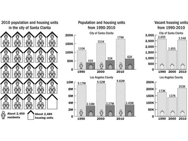
The number of homes in Santa Clarita increased by 18.3 percent during the last decade — the fifth largest increase for any city in Los Angeles County, according to census data released last week.
There were 62,055 housing units in the city in 2010, compared to 52,442 housing units in 2000, according to 2010 U.S. Census data.
The increase in housing units through annexation and construction almost mirrors an overall increase in the city’s population, which jumped about 16 percent in the last decade.
While the number of vacant homes increased to 4 percent in the last decade, the vacancy rate is lower than it was 20 years ago. In 1990, 6 percent of homes in the newly incorporated city were vacant, according to census data.
With a population of 176,320 residents, Santa Clarita is the 24th most populated city in California, and the fourth largest of the 88 cities in the county.
Los Angeles County, meanwhile, added 174,167 housing units overall, an increase of 5.3 percent.
City planners said this week that compared to many cities across California, Santa Clarita home growth is relatively slow.
Including the annexations of the Northpark and Stonecrest communities, the city added 9,613 homes, which includes single family homes and condominiums, during the last year.
The city added about 961 housing units per year over the last decade, according to the data.
To prepare for anticipated future growth within the SCV, city and county officials have spent the past decade working on the “One Valley, One Vision” planning documents.
One Valley, One Vision, or OVOV, is intended to properly regulate growth during the next 50 years.
“A lot of our effort (with OVOV) is about anticipating growth and being prepared for changing economic trends,” said Jason Smisko, a senior city planner. “The land use map kind of represents how we expect to respond to growth over the next several decades.”